
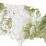
Josef Kellndorfer and Wayne Walker of the Woods Hole Research Center (WHRC) recently worked with colleagues at the U.S. Forest Service and U.S. Geological Survey to create such an inventory for the United States. The map above was built from the National Biomass and Carbon Dataset (NBCD), released in 2011. It depicts the concentration of biomass—a measure of the amount of organic carbon—stored in the trunks, limbs, and leaves of trees. The darkest greens reveal the areas with the densest, tallest, and most robust forest growth.